


An Overview of Moorings Bay
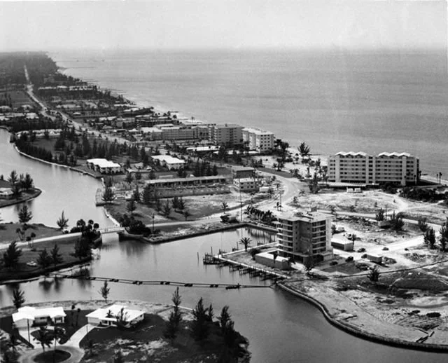
Historically, the waterbody that would come to be known as Moorings Bay was a shallow sheltered bay area dominated by dense mangrove habitat with a single wave-dominated inlet, Doctors Pass, which migrated up and down the undeveloped coastline (FDEP 1997). In 1960, Doctors Pass was widened and dredged in its current location, and two boulder-mound jetties were constructed to prevent migration (FDEP 1997). At the same time in the late 1950s and early 1960s, a large residential development, The Moorings, began construction that would alter the size and shape of Moorings Bay (Reynolds 1982). Within 20 years, development had completely transformed the shape, depth, and size of the waterbody As a result of the long history of alteration and development, Moorings Bay is now considered a completely artificial waterbody (Collier County 1995). Today, Moorings Bay is armored with seawalls and riprap, surrounded by dense urban land use. Sources of water to Moorings Bay include wave and tidal exchange through Doctors Pass; urban stormwater runoff from the surrounding basin; and contributions from Clam Bay to the north. The Florida Department of Environmental Protection (FDEP) currently classifies Moorings Bay as a Class II estuary, meaning the waterbody is designated for shellfish propagation or harvesting. Although no recent records of actual shellfish harvesting exist within Moorings Bay, this designation dictates applicable water quality criteria for the system. (Cardno 2016).
The Moorings Bay System consists of many coves and bays. At the south end is Hurricane Harbor leading to Compass Cove, Bowline Bay, Moorings Bay and Venetian Bay and the north end where it connects to Clam Bay.
The city established the Moorings Bay Taxing District in 1987 for the purpose of improving water quality and navigability of the waterways and to provide maintenance dredging in the canals and waterways within the District, including Doctors Pass. The waterbody is surrounded by the neighborhoods of Coquina Sands, The Moorings and Park Shore and provides recreational and aesthetic values for residents and visitors as well as aquatic habitat.
Water quality is monitored monthly by the City of Naples Natural Resources Department. They conduct sampling at four locations throughout the Bay. Trawling, which involves deploying a large net behind a boat to catch various fish and invertebrate species, is performed quarterly, and species caught are quantified and measured to further our knowledge on what inhabits these waterbodies. This data is used to assess trends and make environmental management decisions.
Please see the links below for information on what you can do to reduce water pollution, the many valuable benefits mangroves provide to the environment and how to maintain them.
-

Benefits of Mangroves
-

Mangrove Trimming Guidelines for Homeowners
-

Water Pollution Prevention
